LoJ: #544 (Pre-LiDAR #547) / 13,130' Pika Peak

Peak Summary
Pika Peak (Now UN13,130, previously UN 13126) is somewhat equally located between the Western Slope and the Front Range with an access off I-70 and Eagle. The peak combines well with "Gold Dust Peak" for a day hike from the Fulford Cave TH. Two wheel vehicles can make it to the trailhead but the last two miles of road get rougher and a vehicle with some additional ground clearance will assure you make it to the TH. Much of the hike is on well-maintained trail and the climbing route is Class 2+. Lidar added 4 feet elevation to this summit.
Pika Peak West Ridge Route
-
-
Fulford Cave - Lake Charles Trailhead
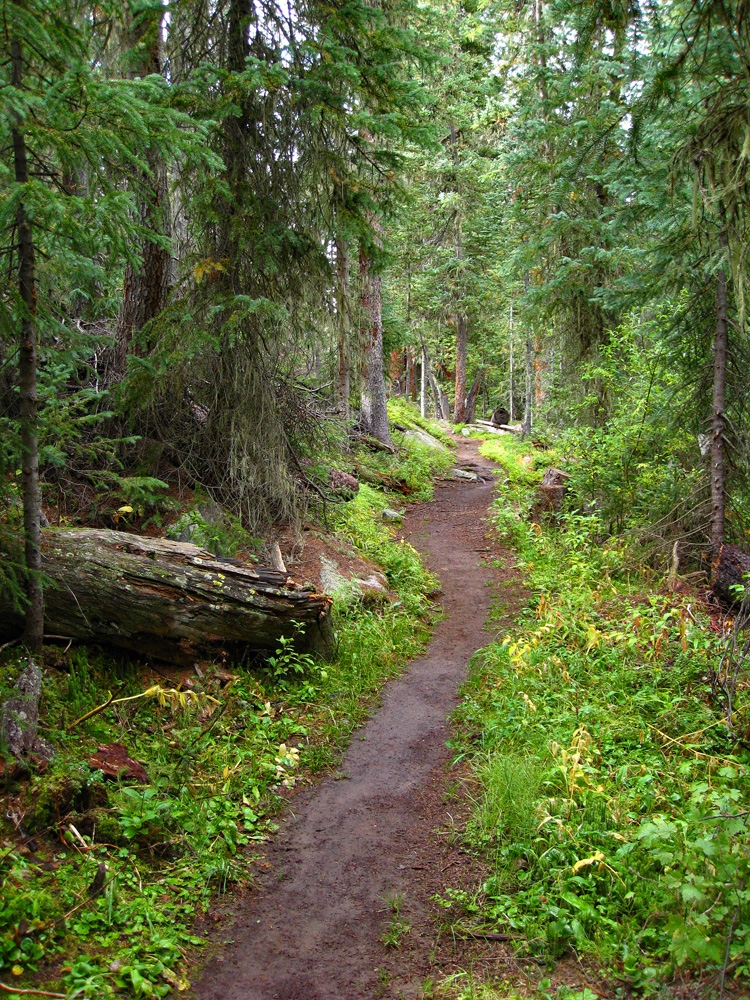
From I-70, take the Eagle exit and drive south across the river. At the traffic circle (3rd roundabout) just across the river, head west on the old US 6 highway. Follow signs to the Sylvan lake State Park turnoff which comes at the next traffic circle, one mile from the previous circle. Drive south and SE on the Sylvan Lake Road through residential areas to an intersection with the Brush Creek Road just after crossing the creek. The Brush Creek road is variously identified as CR307 or FR400. Turn right (SE) and drive 11.8 miles passing an extensive golf course on your right along the way. Past the golf course, at 11.8 miles, turn left (east) onto FR415 at a major, marked intersection. This is a well-graded dirt road that they make efforts to reduce dust on. From this intersection, it is another three miles to where a set of switchbacks begin, then 2.7 more miles to the Yeoman Park CG. Continue on past the turnoff for the campground driving SE. Do not take the turnoff on the left for Fulford, (which road also accesses Nolan Lake TH, and New York Lake TH), but continue on to the terminus of FR415 and a small parking area for the trailhead. The last two miles of this road from Yeoman Park are the only rougher section of road. You might prefer to drive a vehicle with better clearance for this final section but we have seen standard passenger vehicles make it back here. The parking area receives a lot of weekend day use for those hiking up to see Fulford Cave. Walk to the SE end of the parking area and continue following a road bed a short distance to the actual trailhead for two trails: the Iron Edge trail #1873 that leads to the Peter Estin Hut and the Lake Charles Trail #1899. The Lake Charles Trail is the left fork. If you find yourself walking by some cabins, you're on the wrong trail. We measured this trailhead as 19.0 miles from the second traffic circle in Eagle.
Camping
The nicest place to camp is the Yeoman Park CG, two miles back from the TH. There's a nice vault toilet setup here and some designated, fee camping sites. At the actual trailhead, there's a more primitive fee campground, still with vault toilet and six renovated sites, some with tent platforms. Cost is only $8 per night! There is no water and getting stream water would be difficult. Closest water supply is a scummy pond near the parking area. Both campgrounds fill up quickly on summer weekends.
Campsite Locations
Fulford › N 39° 29' 32.1", W 106° 39' 33.2"Elevation 9,440 ft.Yeoman Park › N 39° 30' 09.53", W 106° 40' 45.93"Elevation 9,075 ft.
-
From Gold Dust Peak
Click thumbnail to view full-size photo + caption
Open This Route in a New WindowGold Dust Peak combines well with Pika Peak, its neighbor to the south along a rugged, connecting ridge, so we have sequenced these two. To see the entire hiking route on USGS maps, you'll need both the Mount Jackson and the Crooked Creek Pass quads, or the two Trails Illustrated maps listed. Also, Gary Neben has an alternate approach to Gold Dust from Nolan Creek and the Fulford road. You may also want to consider that approach. Check out the link to Mountain Handbook we provide.
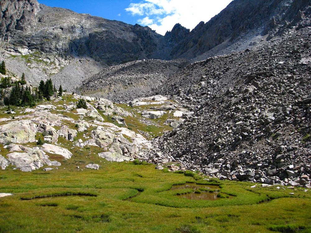
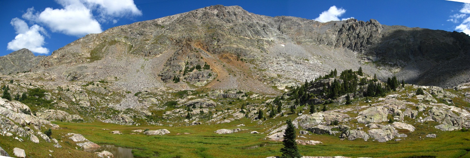
From the trailhead as described, proceed along the relatively flat path for a good 2.5 miles where the trail finally gains some elevation more quickly and then continue on the trail up to a meadow with a small stream coming down from the east that drains Negro Basin below Gold Dust Peak. This is about 3.5 miles in. It should be pointed out that the old survey map shows Gold Dust as being 13,365 ft. high, but G&M and others list it as 13,380 ft. The reason is that the western summit is definitely higher than the eastern one of 13,365 marked on the USGS map, so the western summit elevation has been interpolated to be 13,380 ft. After passing by the unnamed lake at 10,820 ft., begin hiking east into Negro Basin by staying on the south side of the small stream that flows out of the basin and following faint game trails that will enable you to avoid most obstacles.
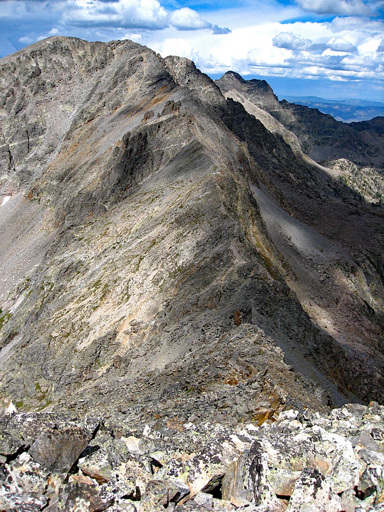
In the upper basin, when you are clear of the trees, pause to study a route up Gold Dust. The most direct route with the fewest problems would be to hike north across the basin and gain the broad, southwest facing flank of the mountain and follow the rounded ridge to the summit. There is a stark contrast between the beautiful basin filled with lush grass and scattered trees to the completely rocky flank. Though there is some tundra to follow, once you begin to ascend out of the basin, most of the remainder of the route will be on medium sized, broken rocks for the next 1,400 feet. On the way you may pass some interesting deposits of quartz and a few crystals, but otherwise, it's just a long slugfest. If you want some assurance you've climbed the peak, go ahead and cross over to the eastern summit. If you're determined to head over to Pika by the connecting ridge, you'll need to go over anyhow. It's just some more minor clambering around but Google Earth seems to confirm the assumption that the west summit is higher.
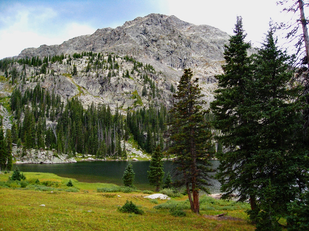
The view from the summit looks right down upon New York Lake, a highly photogenic place that's seldom visited. You can also scope out the connecting ridge over to Pika and see if you want to attempt or if weather will allow. If you don plan to do the ridge, then be sure and follow the link to Gary Neben's report on Mountain Handbook. He rates the ridge as an extended Class 3. Otherwise, start returning back down the west ridge of Gold Dust and drop back into Negro Basin. Gold Dust Peak also has an interesting history in that in 1997 a military jet crashed into the north face of this peak.
Route Description
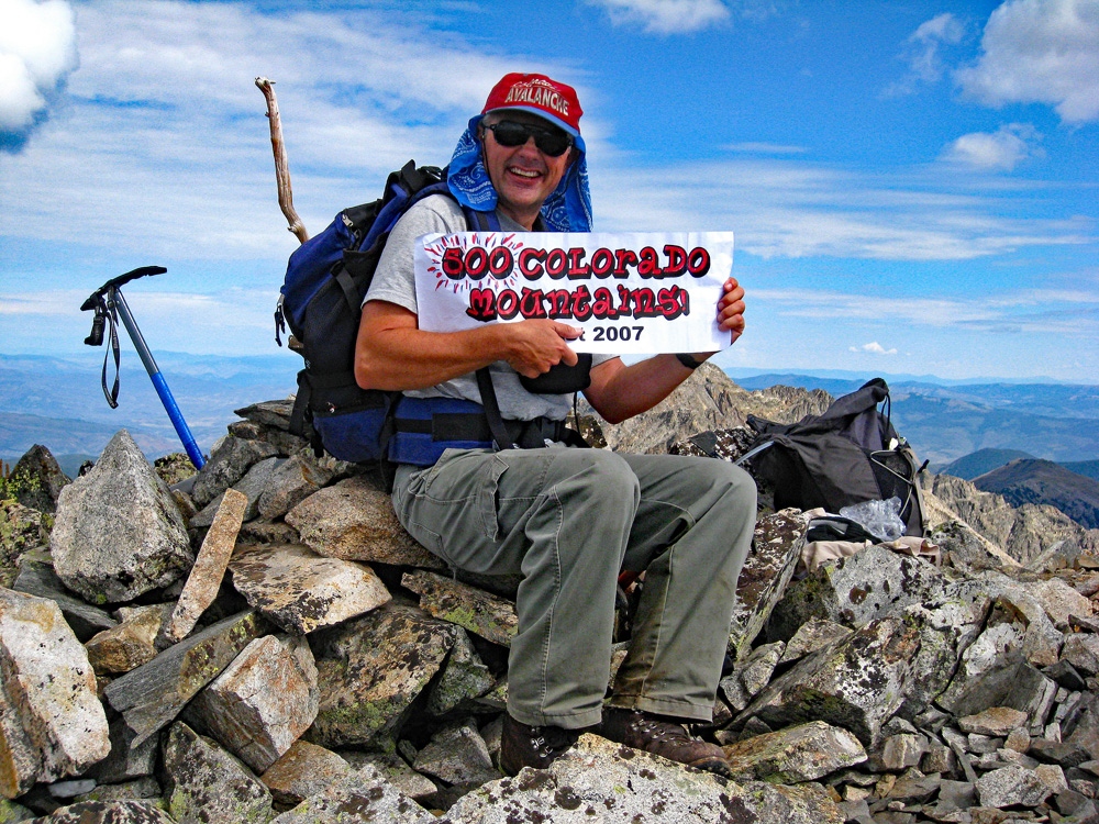
Year Climbed: 2007Pika Peak (UN13,126) is sequenced with Gold Dust Peak and joined by a connecting 3rd class rated ridge. Mileage and elevation gain are measured from the summit of Gold Dust.
The day we climbed these two summits, by the time we left the summit of Gold Dust, thunderstorms were already brewing and the sketchy beta we had regarding the ridge connect from Gold Dust to Pika was that it was at least 3rd class and could take up to three hours. It made little sense to us to be exposed on that ridge to advancing weather, so we took the chicken way out and descended back down into Negro Basin to access Pika. If you want to read a report on doing that ridge, be sure to check out the link provided below to Gary Neben's report on Mountain Handbook. To get to PIka, we headed back down the west ridge of Gold Dust and at about 12,400 ft. dropped back into Negro Basin. We made the tedious descent on all those rocks and entered the basin and crossed the large, flat meadow with the meandering stream and lush grass. We had hoped to see some elk in here, but our presence had long since driven them away. We took a few more pictures here and then began the 1,400 foot ascent to Pika.
The route is easy enough. First, scamper up through a pile of boulders and ascend up to the flatter, narrow finger section of the west ridge at 12,000 ft. through a well-defined slope and trough that will bring you out on the ridge after about 300 feet of gain. Once on the ridge, it's hiking similar to the west flank of Gold Dust, but not quite as rocky. From here, all you have to do is slug it out over mostly medium boulder rubble, and some gravel. We were able to descend Gold Dust and re-ascend Pika and accomplish all that in an hour and a half, but were in really good shape that summer.
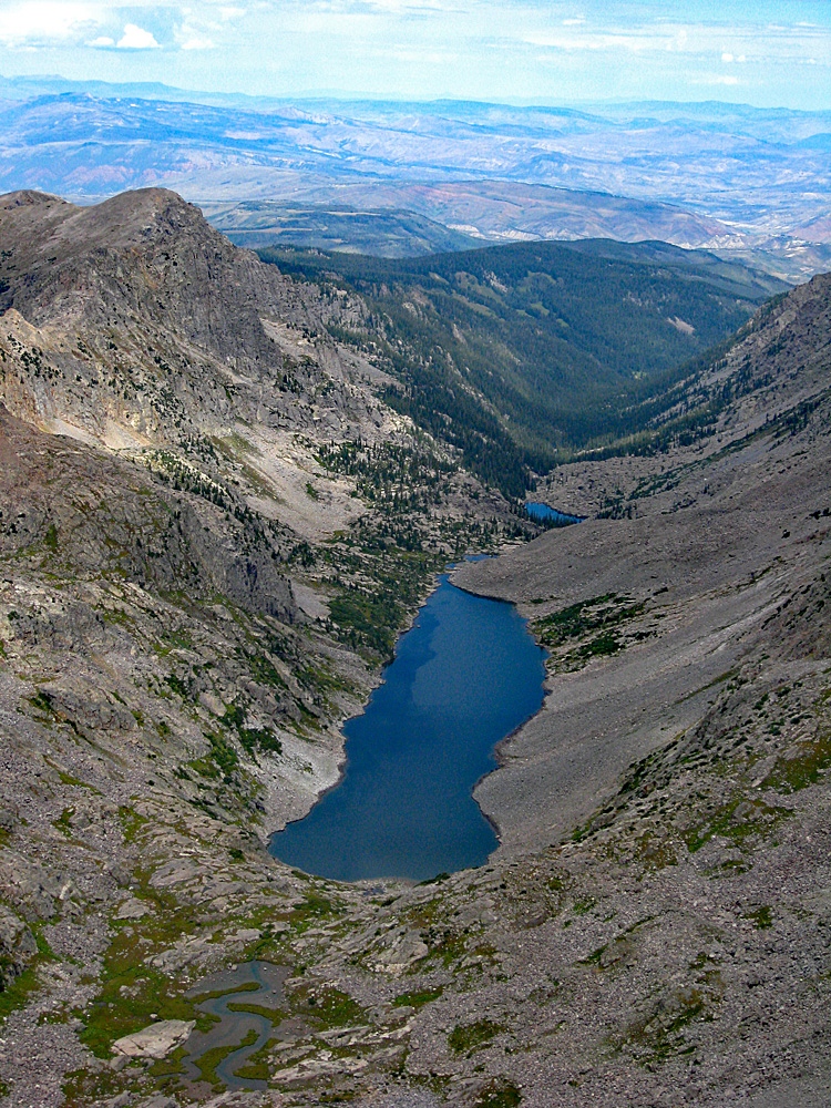
While atop Pika, you may want to check out the view of Mystic Island Lake to the south and towards the head of the valley. To the NE and 1,200 feet down is Big Spruce Lake, Horseshoe Lake and Big Lake, another enticing Sawatch location. To descend, take the west ridge back down. You could exit back into Negro Basin but we wanted to view Lake Charles so we headed down in that direction. There are a few places where you may have to study the route to find the best and easiest passage, but there are no insurmountable obstacles. Lake Charles is a very attractive location and offers some good camping opportunities. From the lake, rejoin the trail and head back to the trailhead about 4.9 miles from the lake.
Additional BETA
Links to other information, routes & trip reports for this peak that may be helpful. -